Pensacola International Airport (PNS)
Orientation and Maps
(Pensacola, Florida (FL), USA)
Located on the northwestern side of Florida and close to the border with Louisiana, the city of Pensacola lies on the coast, overlooking the Gulf of Mexico. One of the most notable cities in this part of Florida, Pensacola has a population of approximately 55,000 and a number of magnificent beach areas.
Standing within the city's northeastern suburbs, the Pensacola Regional Airport (PNS) is connected by taxi cabs, hire cars and local buses. The city's Greyhound bus station is situated along the West Burgess Road and features buses to a number of nearby cities, which include Panama City (3 hours), Miami (15 hours) and New Orleans (4 hours). Those arriving in Pensacola by train will find the Amtrak station is located on East Heinburg Street, with regular trains to California.
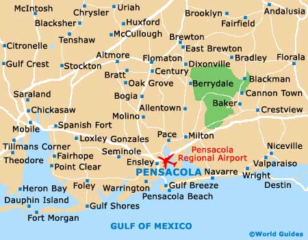
Pensacola Regional Airport (PNS) Maps: Important City Districts
Downtown Pensacola contains the city's prominent business district and amongst the numerous modern buildings are plenty of 19th-century structures. A good selection of restaurants, shops and cultural attractions are scattered around Pensacola's downtown area, being clustered around the Gateway neighborhood and the vibrant waterfront district.
Many people stay in Pensacola purely for the beaches and beautiful stretches of golden sand lie just a short distance to the south of the downtown district. Highlights here include a long pier, from which many people gather to view the spectacular sunsets.
Nearby, the Perdido Key island area of Pensacola covers almost 250 acres / 102 hectares, being an important barrier. If quiet beaches, swimming and stunning views are your bag, this is the place for you, with Perdido Key being easy to reach from mainland Pensacola. Nearby, the Gulf Breeze district is best known for being home to Fort Pickens and the city's popular zoo.
USA Map

Florida Map

Pensacola Map